Great Nicobar Island: Development, Ecology, and the Questions We Cannot Afford to Skip
Introduction: A Strategic Vision, A Complex Reality
Some development decisions raise questions that go beyond scale and investment. The Great Nicobar Island Development Project is one such case where the facts are available, yet the implications remain complex.
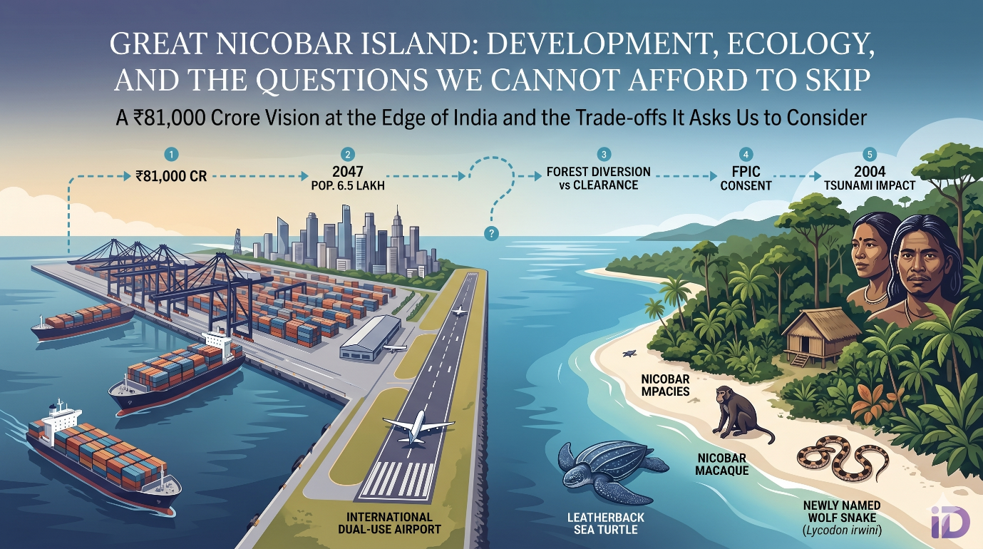
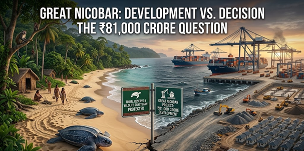
Conceived by NITI Aayog and implemented by the Andaman and Nicobar Islands Integrated Development Corporation (ANIIDCO), the project proposes an international container trans-shipment terminal, a dual-use airport, atownship, and a power complex on India’s southernmost island. The project costs at ₹81,000 crore, with the island’s current population of just over 8,000 expected to grow to nearly 6.5 lakh by 2047.
The strategic rationale is clear. India’s ports lack deep-water berths for large vessels, and cargo is currently routed through Colombo and Singapore at significant revenue cost. A terminal at Galathea Bay, near one of the world’s busiest maritime corridors, would reduce that dependence and strengthen India’s Indo-Pacific presence (PIB, 2026).
This piece examines not whether India needs this infrastructure, but how the trade-offs involved are being framed, interpreted, and understood.
What the Environmental Clearance Process Tells Us
The project received environmental clearance in November 2022 under the EIA Notification, 2006, following the standard appraisal and consultation process. The approval outlines several safeguards covering biodiversity, pollution control, and long-term monitoring and draws on studies by institutions such as the Zoological Survey of India and the Wildlife Instituteof India a (PIB, Environmental Impact Assessment of the Great Nicobar Island Project, 2024)
At the same time, some aspects of the process raise important questions. For instance, approval for forest land diversion came before the final environmental clearance, which may have influenced the extent to which mitigation measures could shape the project’s design.
While the government notes that only a small percentage which is 1.82% of the total forest cover of the Andaman and Nicobar Islands of total forest cover is affected, the ecological concern lies not in quantity alone, but in the nature of the landscape an island ecosystem with high endemism and limited capacity for recovery.
The Biodiversity Picture: Known, Unknown, and Undiscovered
Great Nicobar’s ecological profile is unique. Species have evolved in isolation, making them particularly sensitive to disruption.
The Environmental Clearance incorporates biodiversity conservation plans, coralprotection and translocation measures, and long-term ecological monitoring, supported by financial allocation and institutional oversight. The ecological baseline of the island is still evolving, with several species yet to be fully documented. The Wildlife Institute of India has also indicated that developing comprehensive conservation plans would require at least two years of detailed field research. A bird species endemic to the island remained formally undescribed as of 2026. A wolf snake was scientifically named only in 2025.
This creates an added layer of complexity. Monitoring systems are not only tracking impact they are also identifying it in real time.
The island includes a designated tribal reserve under the Andaman and Nicobar Protection of Aboriginal Tribes Regulation, 1956. Indigenous communities suchas the Shompen and Nicobarese have long-standing relationships with this landscape (Affairs, n.d.).
Communities and the Question of Consent
The government maintains that no displacement is planned and that consultations have been conducted. At the same time, questions have been raised regarding the extent and nature of community consent.
At the ground level, such shifts are not just about infrastructure they reshape how communities interact with their environment and sustain their way of life.
The principle of free, prior, and informed consent, recognised under frameworks like the Forest Rights Act, 2006, remains central to this discussion.
The Seismic Variable
Great Nicobar sits in a seismically active zone atop a major seismic fault line. The 2004 Indian Ocean earthquake and tsunami, which left over 46,000 people injured and at least 40,000 homeless, had a significant physical impact on the island’s southern coastline the same area where the terminal is proposed. On the day of the tsunami, the southern tip of Great Nicobar reportedly subsided by nearly 15 feet, highlighting the region’s geological vulnerability (Disaster Management Directorate, n.d.). The Environmental Clearance includes disaster management conditions, and the government hasstated that a comprehensive plan covering tsunamis and earthquakes is part of the project framework. (MoEFCC, 2022)
While disaster management plans are part of the project framework, their effectiveness depends on transparency, detailed risk modelling, and long-term preparedness especially in the context of large-scale population expansion.
What This Means for Development Practice
The Great Nicobar Projectis not a CSR initiative. Yet, it reflects core questions relevant to development practic
- Are ecological considerations integrated early enough in decision-making?
- Do monitoring systems have the independence and authority to influence outcomes?
- Is community participation substantive or procedural?
The institutional architecture around the project suggests an intent to address these questions.The extent to which it succeeds will depend on implementation.
These are not questions unique to Great Nicobar. They are the central questions of development accountability and the answers will matter long after the first phase of this project is complete.
At DevInsights, our work in CSR advisory, impact assessment, and community engagement is grounded in one principle: meaningful development begins with the people it affects most. The Great Nicobar project is a reminder of what it looks like when that principle is skipped
Conclusion: Beyond Infrastructure
At its core, the Great Nicobar project is about more than infrastructure. It brings into focus how development is approached in regions where ecological and social factors are deeply intertwined.
The larger question, perhaps, is not whether development should take place, but how it accounts for the ecosystems and communities it is likely to affect.
In places like Great Nicobar, progress is not only about what gets built, but also about what is protected and what may not be possible to bring back once changed.
References
Affairs, M. o. (n.d.). Retrieved from https://tribal.nic.in/downloads/PVTG/The%20Andaman%20and%20Nicobar%20Gazette%20dated%2022-05-2015%20-%20Policy%20on%20Shompen%20Tribes%20of%20Great%20Nicobar%20Island.pdf
Disaster Management Directorate, A. a. (n.d.). Earthquake. Andaman and Nicobar Administration. . Retrieved from https://ddm.andamannicobar.gov.in/earthquake
MoEFCC. (2022, 11 11). MoEFCC - Environmental Clearance Letter. Retrieved from chrome-extension://efaidnbmnnnibpcajpcglclefindmkaj/https://aniidco.and.nic.in/announcement/ECL_AUTH_175W92_IA_AN_NCP_260108_2021.pdf
PIB. (2024, August 8). Environmental Impact Assessment of the Great Nicobar Island Project. Retrieved from https://www.pib.gov.in/PressReleasePage.aspx?PRID=2043002®=3&lang=2
PIB. (2026, May 1). Great Nicobar Project: Strategic Importance. Retrieved from static.pib.gov.in